Mt. Marami Maragondon Cavite Climb Guide
Introduction
Mt. Marami is located in the municipality of Maragondon in the province of Cavite. It provides mountaineers with an impressive view of the Cavite mountains and coastline. It is just a two to three hours drive from Metro Manila, as a result, it became one of the most visited mountains near Metro Manila. Mt. Marami has an elevation of 405 meters above sea level or 1328 feet. It is just smaller than its nearby mountain Mt. Pico de Loro. Nevertheless, Mt. Marami and Mt. Pico de Loro have the same attribute such as hiking through forests, farmlands, pillars, towers, and unique rock formations.
Mt. Marami has a total trail length of 22.7 kilometers back and forth. In addition, it has a total elevation gain of 580. The Tagalog word Marami means “many”. It was said that the mountain was named as such due to the numerous gigantic rocks found along the trail. According to its past history, Mt. Marami is below sea level and the original name of the stone chair according to the locals living there is “Nagbuo”.
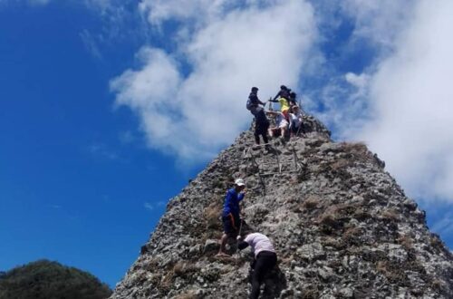
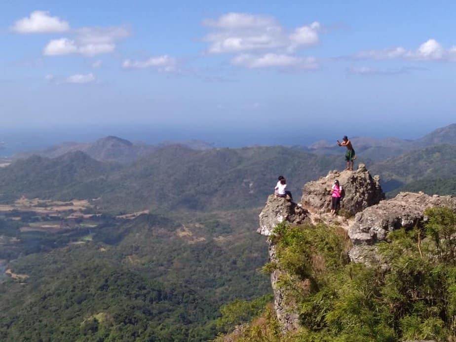
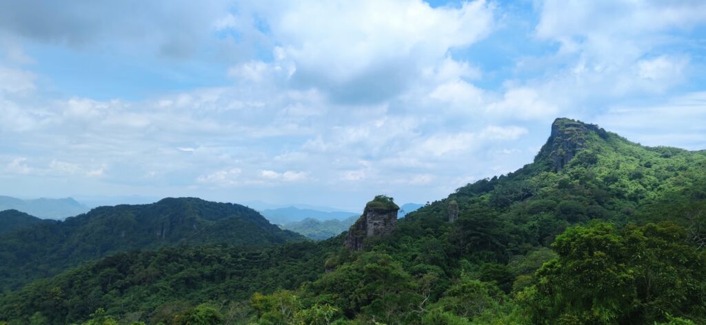
The major jump-off point of Mt. Marami is situated at the Barangay Ramirez in Magallanes municipality. The mountain itself is located in the municipality of Maragondon, but its jump-off point is in Magallanes. Furthermore, the main highlight of climbing Mt. Marami is the iconic stone chair which is a monumental composite of rocky columns located at the summit. The huge composite stone chair gives hikers a 360-degree view of Cavite province.
Name: Mt. Marami
Difficulty: 3/9
Elevation: 405 MASL
Jump-Off: Barangay Ramirez, Magallanes, Cavite or Barangay Talispungo, Maragondon, Cavite
Hours to summit: 3 to 4 hours
Features: stone chair, beautiful wildflowers, and panoramic view of Cavite province and nearby mountains.
My trip to Mt. Marami
We started our climb at 6 am. The previous plan of our group was to start as early as 5:30 am. However, to some unexpected delays and circumstances, it took us nearly three hours for our private van to arrive at the registration point of Mt. Marami. To be honest, I didn’t sleep at all during the entire road trip to see the highways at dawn. In addition, my body is adapting to the night shift environment. Anyway, after our group finish the registration process and got a mountain guide we start to trek.
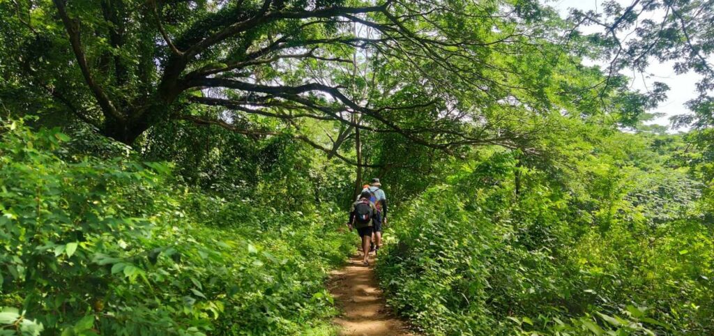
The first part of the entire hike is passing through a well-established cemented road where some residential houses are situated nearby. We greeted the locals living there with a smile and a good morning tone. After that, we pass a downward dirt slope for twenty-three minutes until our group passed the prolonged line of descent which ultimately lead us to the river below.
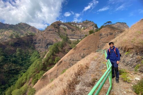
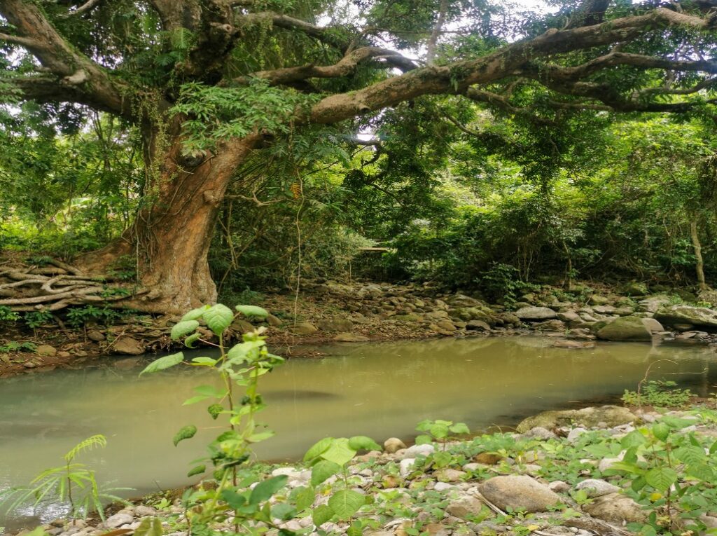
Ryan our group leader lead the way to trek us along the various rocks where we need to pass the dried-up river. Then a few minutes later, we spotted the precipitous assault trail. We take a deep breath and we continue the hike. We climb up the four to five precipitous assaults with several flat surfaces in between.
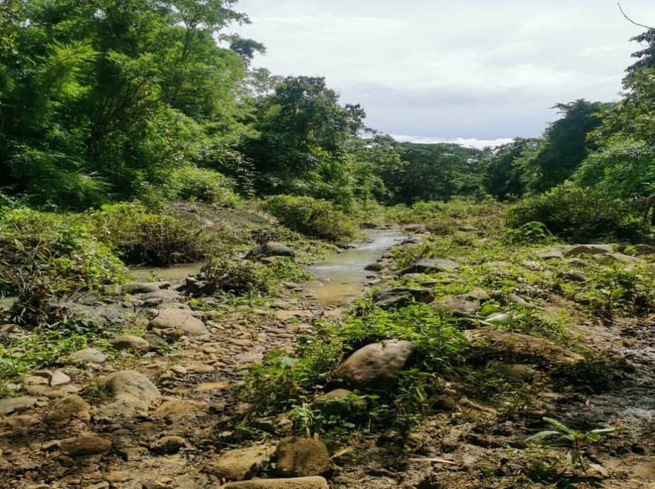
Afterward, we go down the mountain slope and we reach the plain terrain where we can fully see the river. However, at that time, the sun started to rise, and the footpath is so vulnerable to the searing sun. For this reason, some of the members open their umbrellas and some get their caps or head buff inside their hiking backpacks.
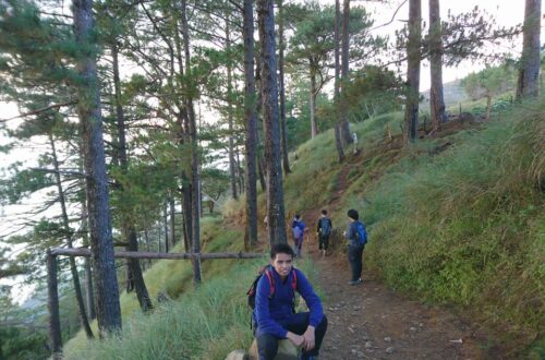
As we continue to hike for nearly thirty minutes in an open field, we found a fine relaxing place under a line of towering trees. It’s indeed a good thing for us because it protects our skin from the taxing heat of the sun. After we rest for twelve minutes, we walk further to see the end of the open field and to our surprise, there’s a descending trail that leads to another dirt and dusty road. Without further ado, we start to descend at a slower pace until we reached the woodland section.
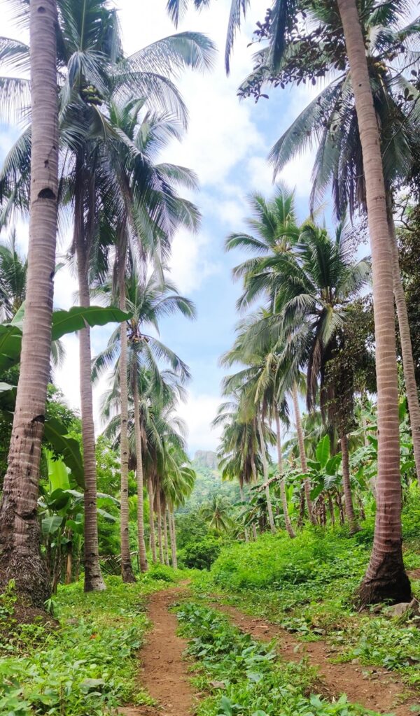
It takes us one hour and ten minutes to pass the vast woodland where we can see some lovely flowers. After we exit the woodland, we pass a broad road with many different kinds of trees. Later, along the way, we saw a pointer on the left side of the tree that says this way to Mt. Marami. So we hurried up and after a few short walks, I can see with my own two eyes the silhouette of Mt. Marami and the so-colled stone chair or in Tagalog “Silyang Bato”.
Our group snaps photos of Mt. Marami from afar and we unwearied for fourteen minutes under the shade of the huge tree. After done resting, we continue to trek for seven minutes going to the second registration point. After a few minutes, Ryan logged our full names and then he paid us the necessary fees. We have a short talk with our mountain guide regarding life in the province and then we resumed the hike passing an uphill and downhill road.
Because of the intense heat of the sun, I drink a lot of water to quench my thirst and tardiness along the way. Then we reached a small hut beside the confined stream and our mountain guide told us that we are near to the summit. He pointed us to the summit of Mt. Marami looming in the background and the straightforward trail leading to the summit. For this reason, we eat chocolates and drink a lot of water to give us energy moving forward.
We resumed the climb before midday and in the middle of the trail, I feel like I was super exhausted already because of the continuous steep ascending. In my opinion, Mt. Marami is more difficult to climb than Mt. Pico de Loro. So we take another rest at the forested trail of Mt. Marami. I take time to breathe in the cool mountain air. As we rest we can see a lot of dried leaves that were dispersed all over the place and flying mosquitoes bothering us. As a result, we only take five-minute rest. We resume the hike and one member of the group named Jen gives her heavy bag to the guide to lessen her burden going up the mountain.
We moved at a faster pace knowing that the summit is within our fingertips. From the forested section and dense flora, we reached the part where bamboo forest dominated our entire vision. The last part of the steeper assault is passing a more concealed pathway and a rocky portion. Afterward, we reached the summit of Mt. Marami. It’s an amazing feeling on top of a small mountain. I’m so amazed by the spectacular scenery.
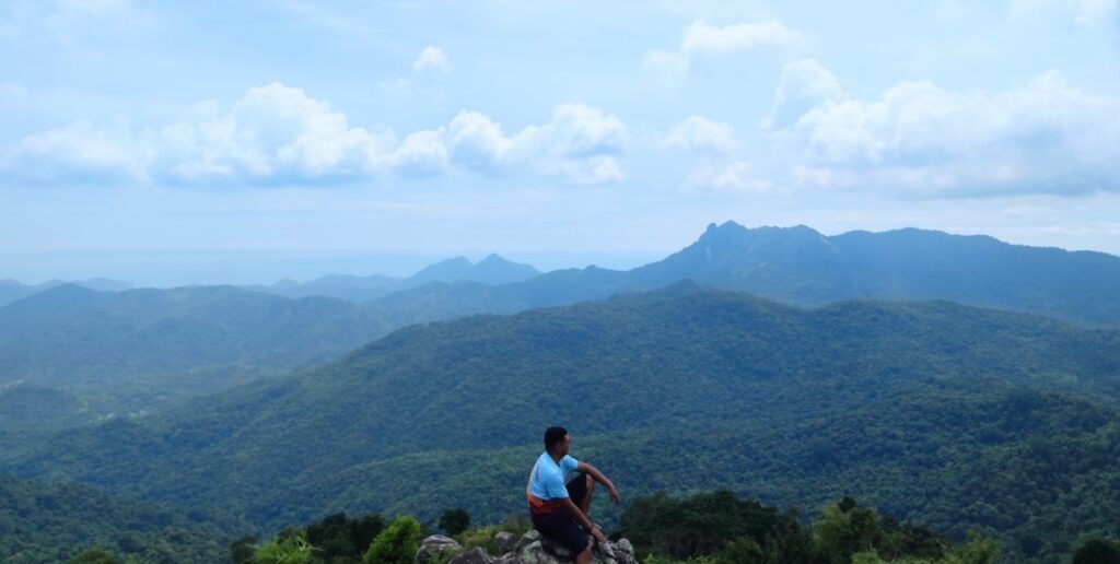
From the summit, we can clearly see the lowlands and coastline of Cavite as well as the famous Mt. Pico de Loro. One by one our group sits on the stone chair and we take pictures of the extensive view of the summit. We unload all the negative energy in our bodies and we stayed on the summit for forty minutes. Afterward, we resume the hike and we go down the mountain so fast and quick. We pass by an 85-degree wall of rocks and a disintegrated trail that stretches for several meters long.
Later the trail become so easy that most of the members do trail running under the blistering sun and gentle white clouds. We keep moving forward on a flat surface composed of tall grasses and soft earth. Along the trail, our guide told our group that Mt. Marami has considered a maze of trails because many hikers lost their way going up and down the mountain especially when there’s no tour guide that leads the way. Also, he told us the reality that before the discovery of Mt. Marami in the past three decades there is a more prominent mountain in Maragondon named Mataas na Gulod which stands at around 300 meters above sea level.
Anyway, after two hours, we reached the walkway going to the base of Mt. Marami. At this moment, I learn to appreciate every little thing in life such as water and energy. Sometimes the simplest things mean the most. Nevertheless, according to one of the group members I have talked to, this is the only minor climb mountain that she will never come back to because the trail is too long that she forgets to know what time is it.
It took us another one hour to reach the jump-off point of Mt. Marami. From there, we rest for a few minutes and then we go to the restroom to take a refreshing bath. We left Magallanes, Cavite late in the afternoon, and past dinner time when we arrived at Pasay City. We bid goodnight to each other and I arrived home feeling great. For this reason, I’m always grateful for God’s undeserved kindness. It was such a great and enjoyable experience to climb Mt. Marami. Nature trip with the best people.
Sample 1 Day itinerary to Mt. Marami
2AM – Call time
2:30AM – ETD going to Magallanes, Cavite
5:15AM – ETA Magallanes, Cavite, breakfast, register, orientation, final preparation and get a tour guide
6:10AM – Start trekking
9AM – Arrive at the nipa hut, refill water, rest, and recharge
11AM – Summit of Mt. Marami, explore, take pictures and take lunch
12PM – Start descent backtrail
4:30PM – Tidy up at the Barangay Ramirez
5:30PM – Homebound
8PM – Arrive at Metro Manila
Note: the above itinerary is not 100 percent sure, and could possibly change depending on the actual pacing of the group and the situation at the time of the event.
Things to bring on your visit to Mt. Marami:
Small flashlight
Extra money, clothes, and slipper
Trail food like peanuts, gorp, chocolate bar, energy bar, apple, and jelly ace
Packed lunch with utensils
2 to 3 liters of bottled water
Umbrella or a cap
Armsleeves
First Aid Kit, toiletries, and personal medicines
Sunscreen
Plastic bag, trash bag
Camera or drones
Valid identification card
Poncho during the rainy season
Whistle (this is optional only)
Trekking pole (this is optional only)
Reminders and Tips:
- Mt. Marami is a minor climb only and the trails are still beginner friendly with some parts that are mildly difficult to navigate during the rainy season.
- The registration will be done at the barangay hall and parking spaces are available at the jump-off point.
- If you don’t want to commute then I highly suggest getting a package tour for efficiency and comfort. Included in the Mt. Marami day tour package is a private van round trip transfer from Metro Manila to Cavite and vice versa, a tour guide fee, gas fee, parking fee, driver’s meal, and entrance fee. The entrance fee is 65 pesos per head at the Talispungo Barangay Hall.
- The guide fee in Mt. Marami will depend on how you negotiate with the tour guide. Based on my experience 500 pesos will be good enough for three to four hikers.
- If you’re commuting only and on a day trip, don’t let yourself or your group reach 5 pm onwards at the Barangay Ramirez because there are no more regular trips. The tricycle driver will offer you a special trip going back to Jollibee, Naic for 600 pesos. So it’s important to bear in mind that starting the climb too late will give you trouble going back to Metro Manila.
- Mt. Marami is not your average mountain. The hike to the summit will last three to four hours at a fast pace and with a few rest only. The total hours to and from the summit could take up to seven to eight hours.
- The toilet and wash area can be found at the jump-off point.
- Avoid any loud music and shouting while trekking.
- If you have more time to explore then ask the locals there or the tour guide where is Pantihan Falls located. It’s only a small waterfall where you can take a relaxing bath. For the tour guide in Mt. Marami and for more information, you can direct message this number 09651995296 or 09269164515 (Vincent Mendoza).
- The tent rental is 400 pesos and it’s available for 4 to 5 people.
- There’s a cellphone signal at the station at the top however it’s not that strong.
- Last but not least, don’t do river crossing if the river is chest deep during the rainy season to prevent any unnecessary accidents.
How to Go to Mt. Marami
By commute
- Ride a bus in the Parañaque Integrated Terminal Exchange (PITX) bound to Naic, Cavite. Tell the bus driver and conductor to drop you off at Jollibee Naic.
- From Jollibee Naic, walk your way for a few meters towards the Shell gasoline station and public market. Then ride a jeep going to Barangay Ramirez and tell the jeepney driver to alight you at the tricycle terminal. After that ride a tricycle going to the Barangay Ramirez registration office of Mt. Marami.
Note: The PITX bus ride fare cost 60 pesos and the jeepney fare going to the Barangay Ramirez is 60 pesos also. The special tricycle fare going to the registration area is 50 pesos.
By private vehicle
- From Metro Manila proceed to Manila–Cavite Expressway (CAVITEX) or Emilio Aguinaldo Highway
- Then take the road going to Tagaytay and Nasugbu. Then turn right to the highway and continue driving until Barangay Talipusngo.
Note: You can pin Talispungo Barangay Hall or Ramirez Barangay Hall on your Waze app for a better direction.
There you have it mountain lover. The moments you have experienced are the only possessions that nobody can take away from you because sometimes you will never know the value of a moment until it becomes a memory. Overall, I hope this Mt. Marami day hike guide has been valuable to you. For any questions, just leave them in the comments below. Until next time and see you on my next hiking trip.
Jervis Ergino
Hi! I’m Jervis Ergino, the digital content creator behind Hike to Mountains, a travel and hiking blog in the Philippines. This blog is dedicated to helping people know more about the best hiking and tourist destinations in the Philippines.